November 13, 2025
GIS Day 2025 discussion: ‘GIS, Landscapes, and the Underground Railroad’
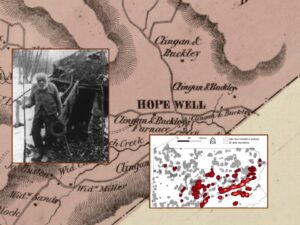 Ben Carter (Muhlenberg) will discuss the role of geographical information systems (GIS) in identifying the role of landscapes in the Underground Railroad. Using remote sensing, machine learning, field survey, and an array of historical documents, he will demonstrate the ways in which the “charcoal lands” around Hopewell Iron Furnace, Berks County, Pa., were deployed by small, rural Black communities and their abolitionist allies to assist those liberating themselves from enslavement in the American South. 4:30-6 p.m. Wed., Nov. 19 • Oechsle Center for Global Education, Room 107 • MORE
Sponsored by the Geospatial Technologies CoP, Lafayette Libraries, Geology, International Affairs, and the Provost Office
Submitted by: John WIlson